Over the past few weeks, my students took on the exhilarating challenge of opening their own travel agency.  Well, not a real, functioning travel agency that real tourists would book through, but one that would take our Spanish II Honors class on a virtual journey through Ecuador, Argentina and Peru.  Students were given the task of creating a 4-7 day itinerary that included various activities and attractions, two different hotels, and popular restaurants in the area. As a teacher, I really enjoyed seeing the students get so excited about their investigations.  On a daily basis, I would hear students gloating about how incredible their excursions are, or how they immediately want to eat the food served in the restaurants they picked.  I can’t even begin to count all of the “wow!” or “that’s so awesome!” comments I heard throughout the class.  Although the main purpose of this lesson was to have students show that they understand enough about a country to plan a travel itinerary, my underlying goal was to have them begin to develop an intrinsic desire and passion for travel and exploring the this incredible world.  I have been fortunate enough to travel with students to Nicaragua, Spain and Italy and have seen firsthand how much that experience has opened their eyes and reshaped how they see themselves and the world in which we live.
By using Google Sites and MyMaps, I was able to give students that have not had the opportunity to travel abroad a glimpse into other cultures, practices and countries. Throughout the project process, students became familiar with 21st century tools such as Google Sheets, MyMaps and Google Sites, three wonderful tools that they can now confidently use moving forward in their personal, academic or professional lives. In addition, students took extreme pride in the appearance and quality of their site and continued to improve it everyday as they each wanted to “out-do†one another. They continued to search for the most interesting hotel, the best restaurants or the strangest excursions. It was great to see how their final products and knowledge were enhanced by the friendly competition in the class.
In order to implement this tool in my classroom, I first had students individually conduct research about their specific country. Next, I provided a template in Google Sheets for students to organize their notes so they could select the restaurants, excursions, and hotels that they would highlight in their travel itinerary. After the students had conducted a significant amount of research on their own, our technology director, Audra Kaplan, came to our classroom to teach the students how to use MyMaps to track their itinerary and how to embed it on the student’s website. I strongly recommend doing this step as it allowed students to ask questions and receive answers on topics that I might not have known. As a class, we had access to 30 Chromebooks which was extremely helpful. However, looking back on this project, I would recommend using the Dell Books or personal laptops as students found that it is easier to insert accents and special characters in Spanish on these devices.
In regards to this specific project, I addressed three Common Core Standards by using Google Sites and MyMaps. First, it addressed Interpretive Communication 2.7 which states, “Read authentic and adapted materials, such as short stories, narratives, advertisements, and brochures.†Students researched authentic materials to develop the knowledge to create their own sites. Next, it addressed Cultures 4.4, which states “Identify distinctive cultural products from the target culture such as toys, clothes, foods, currencies, games, traditional crafts, and musical instrumentsâ€. Throughout this project, students investigated various elements of their chosen country, including many of the aforementioned topics. Students creatively incorporated these elements into their projects based on their personal interests. Lastly, this project addressed Cultures 4.13, which states, “Identify, on maps and globes, the location(s) and major geographic features of countries where the target language is or was usedâ€. By incorporating MyMaps into this project, students were able to visualize where each attraction and landmark is located. They learned how long it would take to travel from one destination to the next and developed a better understanding of the location of the major geographic features of their country and those of their classmates.
Overall, this project was a wonderful success! I’m very happy that I adapted this project in the way that I did as the students were more engaged and it also taught them 21st century skills that they can use in other classes or aspects of their life. I’m looking forward to seeing what trips students plan in the future!
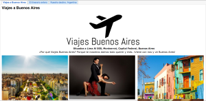
Please Click HERE to explore one of the websites made by two of my students, AinsleyW and CarleyD, from Spanish II Honors.
Massachusetts Foreign Languages Curriculum Framework